Clare Island Abbey St Bridget's Abbey and Tower House The O'Malley, Ó máille, family were lords of Umaill, a territory located around Clew Bay, from the 12th century up until the end of the 16th century. The oldest part of the building is the early 13th century rectangular nave. It is believed Diarmuid Bacach Ó Máille, may have added the two storey tower to the east of the nave, in the middle of the 15th century. The chancel is on the ground floor of the tower and was used as a burial place for the O'Malley Chiefs. The pointed doorway in the west wall of the nave was probably added during this period. During the Dissolution of the monasteries, 1536-1541, by Henry III the abbey was under the Cistercian Abbey of Knockboy.
|
|
|
15th century tower |
The Nave |
The walls and ceiling of the vaulted chancel are decorated with medieval paintings. Amongst the usual medieval bestiary, dragons and griffins etc, there are some scenes depicting hunting and cattle raiding. These rare medieval frescos are probably the finest in Ireland. Due to the deteriorating condition of the paintings, a lot of conservation work has been on going over the past 20 years. NB: I had read on the Clare Island web site that flash photography, for obvious reasons, was not allowed. It was only after I had taken about twenty images that I saw a notice, on the back wall of the chancel, prohibiting any kind of photography. The sign would be better placed just inside the entrance.
|
|
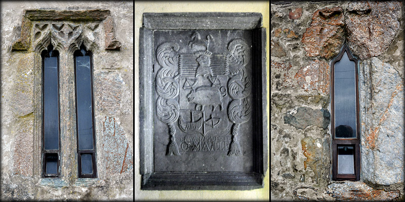
In the centre of the north wall, surrounded by the paintings is a canopied tomb with superb stone tracery. This is rumoured to be the burial place of the legendary Pirate Queen Grace O'Malley-Gráinne Ní Mháille. As well as the tower house on the island, pictured bottom, Grace is also associated with the castles at Carrigahowley and Kildavnet. To the west of the tomb canopy is a wall plaque bearing the O'Malley coat of arms. My trip to the island was curtailed by a continuous downpour, which may have added to the atmosphere at the abbey, but left me no time to visit the castle. I would strongly recommend a visit.
|
|
Pictured below are, a two light window with ogee heads, the O'Malley armorial plaque, and a single ogee headed window.
|
|
|
Situated: Take a ferry from Roonagh Pier, 7 kilometres west of Louisburg, Mayo. The abbey is about 1 kilometre west of Clare Island Pier, along the coast road. Discovery Map 37: L 6893 8447. Last visit June 2017. Longitude: 9° 59' 21" W Latitude: 53° 47' 36" N Photos: Jim Dempsey. |
 |
| Ref: Gosling, Paul. “The Archaeology of Clare Island, Co. Mayo.” Archaeology Ireland, vol. 4, no. 1, 1990, pp. 7–12. JSTOR, www.jstor.org/stable/20562027. | |