Drumlohan Ogham Stones and Souterrain This souterrain was discovered in 1867, when the outer bank of an ecclesiastical enclosure was being removed. Ten ogham stones were used in the construction of the five metre long chamber. In 1936 the chamber was partially dismantled and five of the ogham stones that were used as lintels, are now standing upright next to the chamber. The other five stones were used to line the sides of the souterrain and remain in position. All the stones are greenschist.
|
|
| Doctor Nora White and her colleagues at Ogham in 3d are compiling an excellent digital record of Irelands ogham stones. I will use the same numbers to identify the ogham stones as they do on their web site. Pictured below left is stone number CIIC 275, Drumlohan IV. The inscription on the stone above reads; 'CUNALEGEA MAQI C...SALAR CELI AVI QUECI'. The stone on the right, CIIC 272, Drumlohan I, bears the inscription 'MANU MAGUNO GATI MOCOI MACORBO'. The two stones are standing on the west side of the souterrain. | |
|
|
The two ogham stones below are,on the eastern side, as you look down the open chamber. Pictured left is stone number CIIC 278, Drumlohan VII, the inscription reads; MAQI NET....AS. The first lining ogham stone in the chamber is CIIC 277, Drumlohan VI, it reads; BIR MAQI MUCOI ROTTAIS. |
|
 |
|
| The next three stones pictured are all standing on the eastern side of the chamber. Below left is stone number CIIC 273, Drumlohan II, it reads; CALUNOVIC[A] MAQI MUCOI LIT[ENI]. The next stone is stone number CIIC 276 Drumlohan V. The inscription reads; BIGU MAQI LAG.... | |
|
|
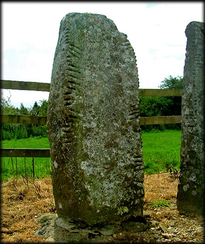
| Below left Ogham stone number CIIC 274 Drumlohan III. This is the tallest of the group, the inscription reads; MAQI INI[--MAQI QE]TTEAS. All the inscriptions above were read by Macalister, R.A.S. Pictured below right are the stones numbered VI and VII and in the bottom image we can see stone number VII in the foreground, with number VIII left of centre, the other two ogham stones, IX and X, are lining the western side of the chamber. | |
|
|
Situated: From Kilmacthomas, Co Waterford, take the N25 west, at the first crossroads take a left for Stradbally at the second crossroads take a right then the next right, about 300 metres down this road you will come to a gate. Go through this gate and follow the path the stones are about 200 metres down this path in a field on your left . Discovery Map 75. S 3658 0139. Longitude: 7° 27' 55" W Latitude: 52° 9' 48" N Photos: Jim Dempsey. |
 |